Contents
Index
Topo Project
StepAction
1 Stadia Reduction
2 Building the DTM
3 Map Production
4 Extracting Sections
5 Volumes
The program is a “general purpose” calculation and drawing package for surveying work. It can accept data in a variety
of forms including that from data recorders, process this data, produce drawings and export the data in a
variety of export formats.
All processing is carried in memory and the results saved to disk at the end of a processing session.
To start a new job select File then New.
This will set up a new job ready for work. If the aim of the session is simply to process some
topographical data and print or plot the results, then the user can proceed with the work and exit.
When you exit, the program will ask whether you wish to save the data and if “yes” is selected
it will allow you to name the file and store it using the windows file management procedures.
If the job is to be a ongoing project, it is better to set up the final data file at the start by selecting
File again and then Save as to record the new file name.
This exercise is to process a small topographical survey where the spot heights
have been observed with a Total station instrument and recorded in the field as Bearing, Distance, Slope Angle
and Height of Prism. These were then entered into a file using the SURV00 data entry program ready for processing.
In the field, the survey started from S112, observed a new station S120, occupied that station and closed
off to S113. S113 was then occupied and later reoccupied for more data.
To process the data select “Topo” and then “Reduce Stadia” and then complete the following menu:
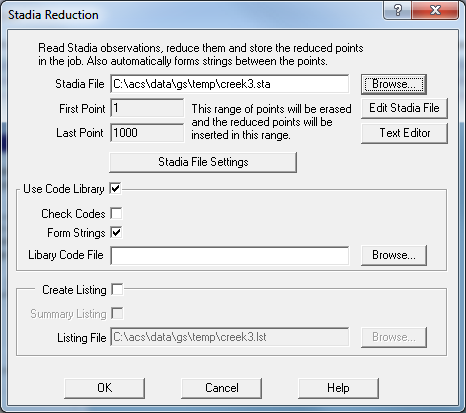
The reduced points are stored by the program and the reduction report is sent to the file “creek3.lst” which is as follows:
ACS Computer Group             Stadia Reduction                          Page: 1
ACSP V4.29      creek3.dat                                             13-Apr-00
********************************************************************************
 PT  SLOPE   HT TGT  VER-ANG HOR-ANG     EASTING   NORTHING   HEIGHT CODE
********************************************************************************
21NM                     1    1000 N   Y
1      Station Defn S113              367383.638 1362555.319   2.484 SN
2      Station Defn S112              366568.620 1362547.997   1.521 SN
3      Station Defn S120              367013.981 1362732.699   2.484 SN

       Setup on Point : 2             366568.620 1362547.997   1.521 SN
Stn:2     Ht inst: 1.650    BM: 4      Azimuth:  0 00 00     Scale: 1.0000
Obs Station : S120    Co-ord diffs:       -0.001     -0.000  -0.004

       Setup on Point : 3             367013.981 1362732.699   2.484 SN
Stn:3     Ht inst: 1.337    BM: 4      Azimuth:  0 00 00     Scale: 1.0000
Obs Station : S112    Co-ord diffs:        0.001      0.000  -0.015
Obs Station : S113    Co-ord diffs:       -0.008      0.000  -0.063
Obs Station : S112    Co-ord diffs:        0.001      0.000  -0.023
4     15.848  2.85    870830  3182730 367003.484 1362744.546   1.763 RD
5     32.356  2.85    882753  3071945 366988.262 1362752.312   1.842 RD
6     49.683  2.85    884948  3042014 366972.965 1362760.717   1.991 RD
7     67.903  2.85    891446  3012438 366956.034 1362768.085   1.873 RD
8     63.377  2.85    900014  3173735 366971.267 1362779.520   0.974
9     50.101  2.85    900225  3315028 366990.337 1362776.870   0.942
10    39.475  2.85    892916    81941 367019.698 1362771.756   1.329
11    41.055  2.85    901522   115118 367022.415 1362772.878   0.792 Hole
12    41.345  2.85    895812   174334 367026.569 1362772.081   0.998
13    47.065  2.85    893107   375748 367042.932 1362769.804   1.372
14    73.149  2.85    894745   604606 367077.814 1362768.420   1.241
15    87.968  2.85    895415   664303 367094.785 1362767.470   1.129
16    101.695 2.85    895217   705521 367110.090 1362765.938   1.212
17    117.272 2.85    895526   735747 367126.689 1362765.096   1.141
18    133.624 2.85    895812   763721 367143.979 1362763.615   1.057
19    151.665 2.85    900108   784531 367162.736 1362762.265   0.939
20    168.9   2.85    900222   811055 367180.885 1362758.591   0.875
21    188.972 2.85    895947   823028 367201.340 1362757.339   1.006
22    206.55  2.85    900117   840851 367219.454 1362753.760   0.919
23    225.509 2.85    900128   851258 367238.704 1362751.506   0.902
24    244.081 2.85    900101   862532 367257.587 1362747.916   0.928
25    262.48  2.85    895946   881617 367276.342 1362740.617   1.021
26    283.89  2.85    895941   885012 367297.812 1362738.463   1.032
27    302.831 2.85    900005   900451 367316.812 1362732.272   1.000
28    322.07  2.85    900012   903543 367336.034 1362729.353   0.991
29    339.12  2.85    900058   913834 367352.962 1362722.977   0.917
30    358.936 2.85    900059   913004 367372.794 1362723.296   0.912
31    375.939 2.85    900144   915955 367389.691 1362719.588   0.827
32    389.638 2.85    900102   921711 367403.309 1362717.154   0.901

       Setup on Point : 1             367383.638 1362555.319   2.484 SN
Stn:1     Ht inst: 1.483    BM: 4      Azimuth:  0 00 00     Scale: 1.0000
Obs Station : S112    Co-ord diffs:        0.006      0.000   0.038
Obs Station : S120    Co-ord diffs:       -0.011     -0.040   0.006
33    169.059 2.85    900508   123330 367420.399 1362720.333   0.885
34    173.553 2.85    900223   185252 367439.802 1362719.533   1.018
35    180.800 2.85    900345   240822 367457.579 1362720.308   0.942
36    192.770 2.85    900238   310454 367483.159 1362720.412   0.993
37    206.688 2.85    900124   360244 367505.261 1362722.435   1.058
38    148.300 2.85    900327    94953 367408.962 1362701.441   0.986 RD
39    129.298 2.85    900316    94913 367405.692 1362682.722   1.010 RD
40    110.028 2.85    900204    94536 367402.291 1362663.754   1.064 RD
41    90.053  2.85    900237    94427 367398.875 1362644.074   1.059 RD
42    70.167  2.85    900918    93326 367395.289 1362624.512   0.936 RD
43    49.949  2.85    901222    85612 367391.398 1362604.661   0.943 RD
44    29.243  2.85    902638    62319 367386.892 1362584.380   0.894 RD
45    11.187  2.85    863811  3512955 367381.987 1362566.364   1.775 RD
Obs Station : S120    Co-ord diffs:        0.005     -0.012   0.026

       Setup on Point : 1             367383.638 1362555.319   2.484 SN
Stn:1     Ht inst: 1.521    BM: 4      Azimuth:  0 00 00     Scale: 1.0000
Obs Station : S120    Co-ord diffs:        0.006     -0.003   0.051
46    222.880 2.85    900644    83835 367417.130 1362775.668   0.745
47    204.473 2.85    900525    95213 367418.687 1362756.766   0.858 RD
48    183.160 2.85    900206    94311 367414.559 1362735.850   1.065
49    161.625 2.85    900127    94554 367411.050 1362714.603   1.106 RD
50    161.127 2.85    900346  3452149 367342.923 1362711.217   0.998
51    148.94  2.85    900503  3531230 367366.023 1362703.214   0.954
52    140.844 2.85    900530    14434 367387.920 1362696.098   0.947
53    176.052 2.85    900217   241855 367456.128 1362715.755   1.059
54    170.136 2.85    900105   181522 367436.935 1362716.892   1.122
55    164.307 2.85    900721   112201 367416.020 1362716.403   0.824
56    222.401 2.85    900351   100113 367422.333 1362774.328   0.933 RD
57    209.241 2.85    900327   104037 367422.403 1362760.938   0.970 Pipe
58    208.814 1.85    901951    92312 367417.693 1362761.334   0.975 Pipe
59    181.155 2.85    900427   103822 367417.083 1362733.360   0.942 Pipe
60    181.369 2.85    900424    90959 367412.529 1362734.372   0.945 Pipe
61    157.270 2.85    901031   124004 367418.126 1362708.760   0.693 PP
62    12.865  2.85    911830   393915 367391.846 1362565.221   0.863 PP
70 Points created  0 Errors
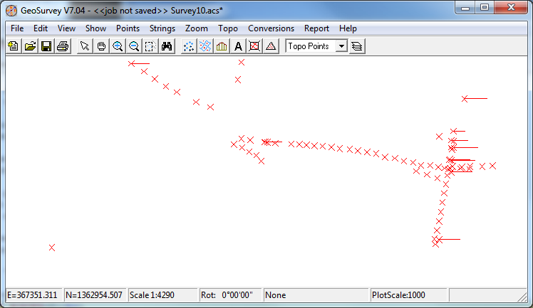
After processing the data it is displayed as follows:
Building the DTM
Map Production
Extracting Sections
Volumes